Collection includes seventeen photographs documenting the destructive effects of hydraulic mining. Includes images of washed-... J.A. Todd was active as a photographer in California between 1863-1897. "In 1882, Todd was commissioned to take a series of p...
Written on mount: Todd 1 No. 2900 U.S. Circuit Court, Cal. Edwards Woodruff v. North Bloomfield Gravel Mining Co. et al. File... Title supplied by cataloger. In 1882 J.A. Todd was commissioned to take photographs documenting damaging effects of hydraulic mining to be used in the cas...
Written on mount: Todd No. 2 No. 2900 U.S. Circuit Court, Cal. Edwards Woodruff v. North Bloomfield Gravel Mining Co. et al. ... Title supplied by cataloger. In 1882 J.A. Todd was commissioned to take photographs documenting damaging effects of hydraulic mining to be used in the cas...
Written on mount: Todd No. 3 No. 2900 U.S. Circuit Court, Cal. Edwards Woodruff v. North Bloomfield Gravel Mining Co. et al. ... Title supplied by cataloger. In 1882 J.A. Todd was commissioned to take photographs documenting damaging effects of hydraulic mining to be used in the cas...
Written on mount: Todd No. 4 No. 2900 U.S. Circuit Court, Cal. Edwards Woodruff v. North Bloomfield Gravel Mining Co. et al. ... Title supplied by cataloger. In 1882 J.A. Todd was commissioned to take photographs documenting damaging effects of hydraulic mining to be used in the cas...
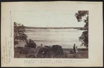
Written on mount: Todd No. 5 No. 2900 U.S. Circuit Court, Cal. Edwards Woodruff v. North Bloomfield Gravel Mining Co. et al. ... Title supplied by cataloger. In 1882 J.A. Todd was commissioned to take photographs documenting damaging effects of hydraulic mining to be used in the cas...
Written on mount: Todd No. 6 No. 2900 U.S. Circuit Court, Cal. Edwards Woodruff v. North Bloomfield Gravel Mining Co. et al. ... Title supplied by cataloger. In 1882 J.A. Todd was commissioned to take photographs documenting damaging effects of hydraulic mining to be used in the cas...
Written on mount: Todd No. 7 No. 2900 U.S. Circuit Court, Cal. Edwards Woodruff v. North Bloomfield Gravel Mining Co. et al. ... Title supplied by cataloger. In 1882 J.A. Todd was commissioned to take photographs documenting damaging effects of hydraulic mining to be used in the cas...
Written on mount: Todd No. 8 No. 2900 U.S. Circuit Court, Cal. Edwards Woodruff v. North Bloomfield Gravel Mining Co. et al. ... Written on mount: Site of the old road leading up to Simpson's Bridge In 1882 J.A. Todd was commissioned to take photographs documenting damaging effects of hydraulic mining to be used in the cas...
Written on mount: Complainants Exhibit Todd No. 9 No. 2900 U.S. Circuit Court, Cal. Edwards Woodruff v. North Bloomfield Grav... Written on mount: Shows a breast of sand gravel eight and ten feet deep, deposited in 1881 at the south end of the Yuba River... In 1882 J.A. Todd was commissioned to take photographs documenting damaging effects of hydraulic mining to be used in the cas...
Written on mount: Complainants Exhibit Todd No. 10 No. 2900 U.S. Circuit Court, Cal. Edwards Woodruff v. North Bloomfield Gra... Written on mount: View of a portion of the levee that surrounds Marysville, as seen from the north end of the Yuba River brid... In 1882 J.A. Todd was commissioned to take photographs documenting damaging effects of hydraulic mining to be used in the cas...
Written on mount:Complainants Exhibit Todd No. 11 No. 2900 U.S. Circuit Court, Cal. Edwards Woodruff v. North Bloomfield Grav... Written on mount: Shows to the right the devastated [illegible] lands fromerly known as Brigg's orchard. In the center the no... In 1882 J.A. Todd was commissioned to take photographs documenting damaging effects of hydraulic mining to be used in the cas...
Written on mount: Complainants Exhibit Todd No. 12 No. 2900 U.S. Circuit Court, Cal. Edwards Woodruff v. North Bloomfield Gra... Written on mount: View in Sutter County 36 miles below Marysville; where formerly existed the orchards of Mr. Briggs and Mr. ... In 1882 J.A. Todd was commissioned to take photographs documenting damaging effects of hydraulic mining to be used in the cas...
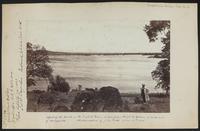
Written on mount: Complainants Exhibit Todd No. 13 No. 2900 U.S. Circuit Court, Cal. Edwards Woodruff v. North Bloomfield Gra... Written on mount: View from the levee at Yuba City, Sutter County, looking east up the Yuba River towards Marysville. Feather... In 1882 J.A. Todd was commissioned to take photographs documenting damaging effects of hydraulic mining to be used in the cas...
Written on mount: Complainants Exhibit Todd No. 14 No. 2900 U.S. Circuit Court, Cal. Edwards Woodruff v. North Bloomfield Gra... Written on mount: View showing the break near the center of what is known as the Parks Brush Dam, above Marysville and the Yu... In 1882 J.A. Todd was commissioned to take photographs documenting damaging effects of hydraulic mining to be used in the cas...
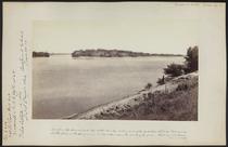
Written on mount: Complainants Exhibit Todd No. 15 No. 2900 U.S. Circuit Court, Cal. Edwards Woodruff v. North Bloomfield Gra... Written on mount: View as seen from Point Guerrero on the Yuba River, looking towards Marysville In 1882 J.A. Todd was commissioned to take photographs documenting damaging effects of hydraulic mining to be used in the cas...
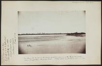
Written on mount: Complainants Exhibit Todd No. 16 No. 2900 U.S. Circuit Court, Cal. Edwards Woodruff v. North Bloomfield Gra... Written on mount: Effect of the break in the English Dam, as seen from Point Guerrero, 10 miles east of Marysville In 1882 J.A. Todd was commissioned to take photographs documenting damaging effects of hydraulic mining to be used in the cas...
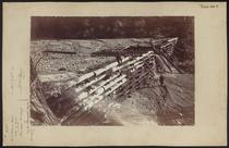
Written on mount: Complainants Exhibit Todd No. 17 No. 2900 U.S. Circuit Court, Cal. Edwards Woodruff v. North Bloomfield Gra... Written on mount: Shows the break in the North head of the Parks Brush Dam on the Yuba River In 1882 J.A. Todd was commissioned to take photographs documenting damaging effects of hydraulic mining to be used in the cas...