Jump to navigation
Items
Pages
-

-
Los Palos Verdes, southeast of bench mark 157, about 175 ft. elevation
-

-
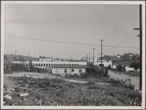
Looking west from roof of central manufacturing district (Vernon)
-

-
Looking north-northwest from roof of central manufacturing district (Vernon)
-

-
Looking south-southwest from roof of central manufacturing district (Vernon); residential town of Maywood in distance
-

-
Los Angeles River near central manufacturing district (Vernon), looking east; land wagon, oil tank wagon, power line
-

-
Los Angeles River near central manufacturing district (Vernon), looking northeast; storm drains
-

-
Steel industry on Slauson Avenue, west of Maywood looking from northwest
-

-
Irrigated cabbage field with asparagus in the distance; Chinese ranch house with water well in right background; manufacturing plant
-

-
Typical rear view of stucco house, looking south from west of Mission Place on Florence Avenue, Walnut Park
-

-
Looking northwest from Occidental College toward Eagle Rock Boulevard
-

-
Cheap structures on Eagle Rock Boulevard, looking east from north of York Boulevard
-

-
Looking west from Toland Place, Highland Park, York Valley
-

-
Looking southwest from North 45 Avenue, west of South Eagle Place; electrical light wire poles on barren hills
-
-
Three artesian water companies in York Valley
-

-
Looking north from southwest of McCarthy Drive and Verdugo Road, walnut trees, reservoir in background
-

-
House construction, north side of Verdugo Road
-

-
Looking north from Palmer Drive
-

-
Looking across Pershing Square from 6th and Olive Streets
-

-
Looking toward beach from west of Montana Avenue, Santa Monica
-

-
Mouth of Santa Monica Canyon, looking northeast
-

-
Mouth of Santa Monica Canyon, looking northwest
-

-
Sycamores in Santa Monica Canyon at entrance, looking northeast
-

-
Mouth of Santa Monica Canyon from northeast
-

-
Looking south over mouth of Santa Monica Canyon
Pages
